Day 19: Cowboy Camping for my First Time Ever

September 10th: Middle Rae Lake – Center Basin Creek Crossing (10.5 miles, 2,490′ elevation gain)

Cumulative Distance: 207.6 miles

Cumulative Ascent: 37,365 feet

IMG_5250

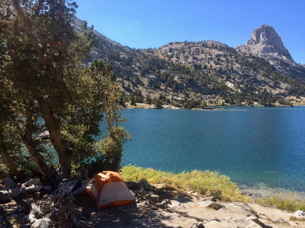
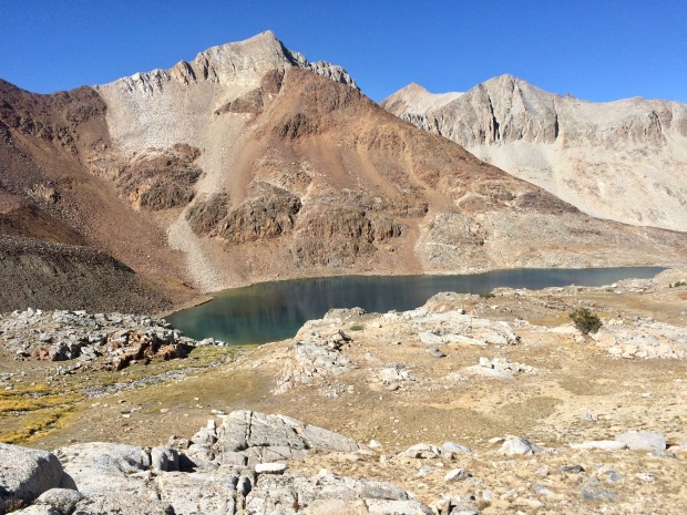
The morning sun creeping its way toward me and Fin Dome looking out over Middle Rae Lake

I woke up, unrested, and was begrudgingly on the tail by 0730. As I turned onto the main trail from the campground I ran into Mark and was surprised the group was up so early! Apparently, as I had suspected, they hadn’t been that far off from where I was- tucked around the corner and behind some large rocks on the other side of the campground.

It was a long, slow, miserable slog up Glen Pass. I kept looking up at this giant wall in front of me and cursing the hikers who had kept me up the night prior. I could have stopped anywhere and fallen back to sleep. In my journal I wrote that the only thought going through my mind at the top of the pass was, “womp.” If that doesn’t sum up my morning in one word, then I don’t know what would.

IMG_5252

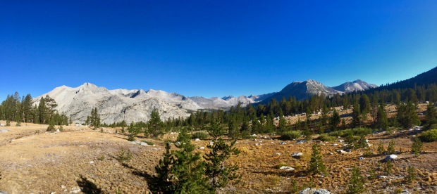
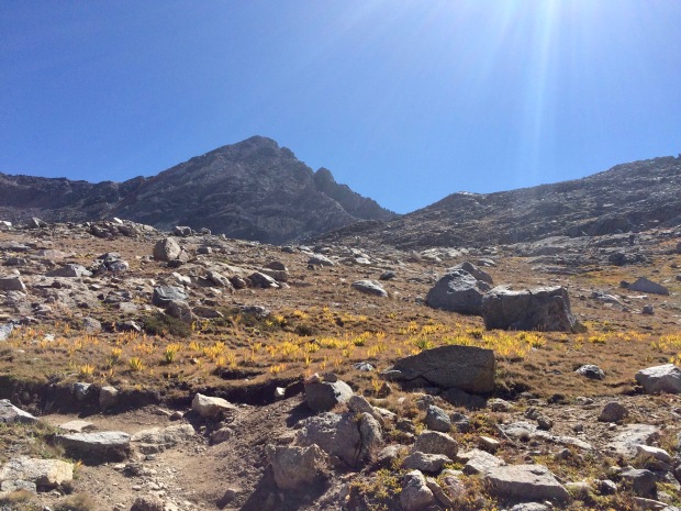
Dragon Peak, the Painted Lady, and Glen Pass. Bring it.

IMG_5255

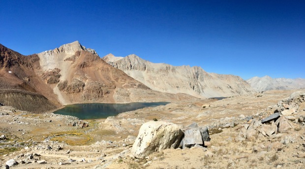
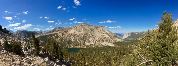
Standing on the isthmus between Middle and Upper Rae Lakes, Black Mountain reflecting in the water

IMG_5256

Okay, hi, giant wall of doom. I didn’t need sleep anyway. No Biggie.

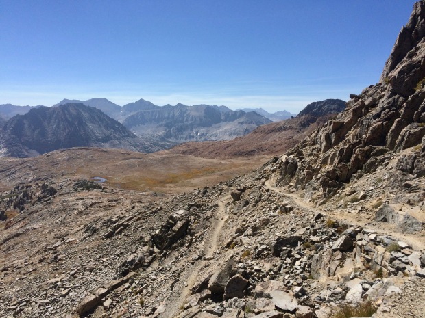
Glen Pass was a tight squeeze without the normal room to spread out and chill for a bit with a snack to take in the views. The scenery back toward Rae Lakes was astounding, but the expansive view out to the Great Western Divide was behind the far wall of the cwm on the south side. However, its little unnamed tarn was a brilliant shining blue and looked tempting to jump into. There were a bunch of people up there on the pass, so I went, “meh,” and headed down the other side into its cwm.

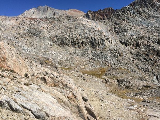
A cwm, or bowl, or cirque, or corrie- take your pick- is cut out from glacier erosion. The ice and rock debris impact and converge carving out a steep headwall down into a bowl-like shape with three walls. This ice/rock flow leaves a deep tarn in its wake, which, in this case, is the unnamed south side lake seen a few photos down below. Just on the tarn’s other side was a rock glacier hanging out… chilling (heh). I thought it was just a colluvial fan, but turns out I’m wrong and it’s actually a rock glacier that took over the terminal moraine, which is way cooler (heh) anyway.

IMG_5257

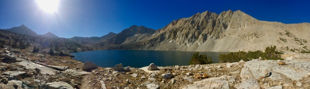
Diamond Peak, Black Mountain, some unnamed lakes, and Rae Lakes

IMG_5258

North side of Glen Pass and the teeeeeniest, tiiiiiiniest cloud you ever did see

IMG_5259

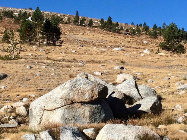
And let’s do a little twirl over this way to look down the south side. See how narrow the pass is? Not enough room for morning snack craving hangouts if there’s more than even one little marmot guy up there.

IMG_5261

Looking down the cwm to an unnamed tarn and a little rock glacier peaking out of the shadows

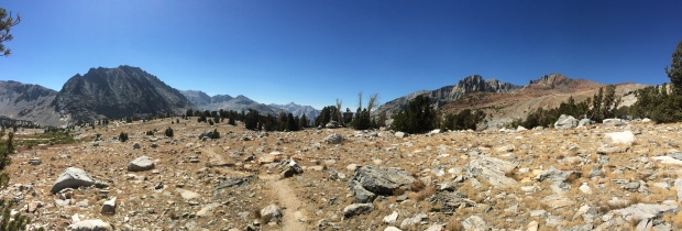
I passed by a couple mule trains on the way down and approached a gorgeous view out over Charlotte Lake and Charlotte Dome. I ran into the whole Palisade Crew at the Kearsarge Pass Junction where they were exiting, parting ways with Tim who would continue on by himself out Whitney Portal.

IMG_5262

Dem switchbacks tho. 

IMG_5263

Looking back up. Hi. Bye.

IMG_5264

Charlotte Dome

IMG_5265

Finally able to get a great view of the Great Western Divide now that I’m out of the cwm

IMG_5266

Mt. Bago and Charlotte Lake with Charlotte Dome way out there

IMG_5267

Okay. I wish this shot didn’t come out so blurry because it’s honestly one of my favorite photos from my entire hike.

IMG_5268

Charlotte Lake

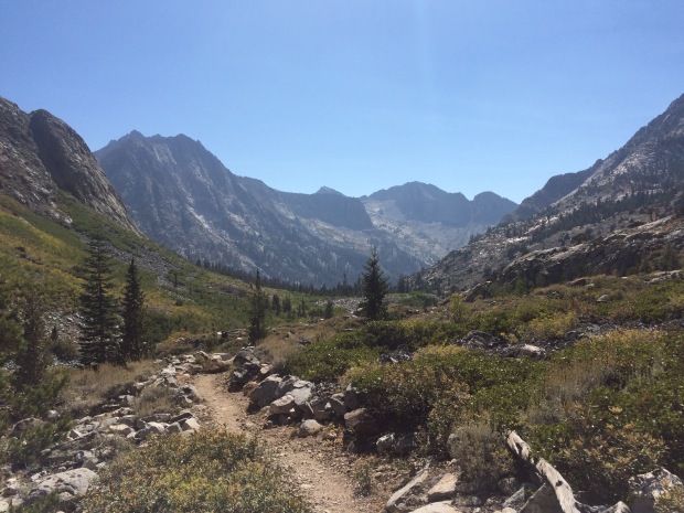
After passing Charlotte Lake I was on my way down to Vidette Meadow, which sits at the base of the imposing near-vertical walls of an arête called East Vidette. Arêtes are formed when two glaciers flow parallel to each other carving out separate valleys with a sharp edge (French: arête) between them. You might remember another arête called The Hermit that I wrote about on Day 13.

Down and down I eventually got to the Bubbs Creek Junction and had to pull over. My insides were on fire and I felt like I would vomit at any moment. The pain was unbearable so I dropped my pack, climbed up onto a flat rock, curled up in a ball on my side, and almost started crying. It came hard and out of absolutely nowhere. My pack’s belt strap didn’t help by adding so much pressure to my stomach. I could feel the blood draining from my face and knew I probably looked awful. I honestly don’t remember how long I stayed there, but it definitely wasn’t just a few minutes. It took every bit of me to force myself up to continue on.

IMG_5270

Je m’arrête to take a photo of the arêtes. East Vidette looking fierce and another, Center Peak, in the distance at the top of Center Basin

IMG_5277

Potentially West Vidette? Maybe? Sure.

IMG_5278

PIKACHU!

IMG_5280

ZOOM!

IMG_5282

East Vidette arête looking down on me, disappointed. “Get your ass up and stop complaining.”

The next day would be Forester Pass, which I had heard horror stories about. It would be the highest I’ve ever hiked and the last major pass until Whitney. I needed to set myself up for success tonight in order to get a good start the next morning. Tim had mentioned a campsite a mile or so past Center Basin Creek crossing, and that would be my ultimate goal, but with the way my stomach was feeling, I’d settle for Upper Vidette Meadow at worst.

So up it was. I kept stopping every 200 feet, wincing in pain. Times like this called for some serious inner-mantra chants. A few that stuck were, “This fucking trail isn’t going to hike its fucking self;” “Too legit, too legit to quit;” and “Every step is literally one step closer, Jaimie.”

It was a painful morning with the struggle up Glen half-awake and now this insane stomach pain, but I somehow managed to get up to Center Basin Creek crossing. I know I’ve said it before, but it’s amazing how it’s 90% mental and only 10% physical. Being alone was a blessing because everything was at my own pace and it proved to me how capable I truly am. Maybe that’s what got me through the bad days- just knowing, deep down, that I was (am) strong enough and letting that inner pride take care of the rest.

IMG_5283

Following Bubbs Creek upstream, Kearsarge Pinnacles on the left

I found a great open site not too far off from the trail next to Center Basin Creek and set up for the night. I was completely alone again for another night and was reflecting a lot on the past 200 (!!!) miles I had put behind me. Despite the bad days, I had a sudden sadness fall over me: I’d be done with this journey in three days. Then what? It was the first time I really sat down and pieced everything together where it finally made sense. Most days were spent looking forward to the next- looking forward, excited to put miles behind me. But that afternoon was different. I was sad that it was all ending.

The occasional hiker would wave as they passed by, most likely trying to get up to that same site I had set out to find along with Tim. Then suddenly I saw a familiar face coming up the trail… “GABRIEL?!”

Let’s bring it waaaaaaay back to my Day 1 post. The day before I started, Jace and I waited in line in Yosemite before the sun came up to grab him a walk-up wilderness permit. We were behind a guy named Gabriel, who I saw one other time at Red’s Meadow, and here he was again!

He came over to chat for a bit and then asked if I’d mind if he camped with me for the night.

We ate dinner together, swapped life stories, and he set up his ground cover. I looked on with envy- I had been wanting to cowboy camp and hadn’t mustered up the courage yet to do so. “You should try it! Just keep your tent set up over there and if you get scared or cold in the middle of the night you can always go back in.” So I pulled the footprint out from under my tent, grabbed my sleeping pad and sleeping bag, and snuggled in for the night. Looking in the distance toward Forester Pass, the clouds were gathering and looking dark. Hopefully the rain would hold off for the night, and fingers crossed I’d get up and over Forester without any storms tomorrow.


IMG_5286

Building clouds making me slightly nervous

Every night in my tent, I’d journal about the day and look over maps for the day ahead. This also included reading about what lay ahead the next day from Elizabeth Wenk’s Essential Guide to the JMT. Gabriel had had a little ritual each night with some other ladies he had been hiking with where they’d read the Wenk book out loud for the section ahead before going to bed. He asked if I was down for doing that, so we took turns reading paragraphs out loud and it was an awesome way to end the night. We laughed at the ridiculous names for some of the wildflowers that we wouldn’t even be seeing this late in the season and passed out.

Little side note here: I have to say that people turn up in your life for all sorts of different reasons. G walking into camp that night changed the rest of my hike and I found in him a dear friend who I look up to and respect endlessly. We’d spend the next couple days hiking together and I couldn’t have asked for a better way to finish those 220 miles to Whitney than with him by my side.

It had been a rough day physically, and I was realizing that mentally I was starting to feel a sadness welling up inside of me that everything would soon be ending. But I had gotten through the day, the stomach pain went away, and the night ended with laughs with a friend. I fell asleep under the stars without a thin sheet of nylon between me and them for the first time in my life.

IMG_5285

COWBOY CAMPING: SUCCESS 

Day 18: My Easiest Day on the Trail

September 9th: Woods Creek – Middle Rae Lake (6.4 miles, 2,100′ elevation gain)

Cumulative Distance: 197.1 miles

Cumulative Ascent: 34,875 feet

I woke up at 0630 to make sure I’d get to Rae Lakes before the crazy influx of weekend backpackers, but didn’t end up leaving camp until shortly after 0800. Oh, yeah. Something I forgot to mention in my last post is that Woods Creek was the lowest I’d be for the rest of my journey until heading down the other side of Mt. Whitney. So I won’t be back below 9,500′ for four more days. Pretty neat. AAAANYWAY…

Overall, it was a pretty uneventful day, and ridiculously easy, so this’ll be a short li’l guy.

Shortly down the trail I came across quite the scene of carnage. Scattered berries everywhere and the remnants of what I’m assuming is a decapitated hawk. It looked super fresh and gave me the heebie jeebies that something was out there… mountain lion? I’ve always grown up knowing felines typically decapitate their prey and pull out some organs, sometimes raccoons and owls… but this was a pretty decent sized hawk. Moving on…

IMG_5220

Poor guy

As I got closer to Rae Lakes, I passed by more people, and the comments from most of the men were so condescending, it took every bit of my feminist pride to carry on to my destination. Lots of mansplaining and snide comments about me being out at Rae Lakes alone… when one dude asked where I was coming from and I replied, “Yosemite” his tune drastically changed and I could tell he was embarrassed for the lecture. Let’s just insert a giant eyeroll here, okay?

Dollar Lake was picturesque and I sat there for a bit on the shore watching some people fish. But the most insanely perfect part of the day was approaching the first glimpse of Fin Dome with meadows and creeks in the foreground. It was as if I were staring at a painting.

IMG_5222

Dollar Lake

IMG_5223

Dragon Peak, the Painted Lady, Fin Dome, and this marshy piece of meadowy heaven

IMG_5224

Entering Rae Lakes basin

IMG_5226

Kinda basin-y

IMG_5227

Oh, yeah. That’s a basin

I eventually approached Lower Rae Lake and skirted my way around to Middle Rae Lake where I was able to grab any site I wanted. I found an established site under a tree up above the water and fell in love. I had the whole area to myself for a couple hours until more hikers showed up. Next to me rolled up the guy who camped next to me at South Fork Kings Crossing- Alan, a retired LAFD who spends his retirement mountaineering all over the world and backpacking on the west coast.  Him and I ended up hiking together here and there the past couple days and I learned a lot from him, especially concerning how to breathe better with my asthma.

I never ended up seeing the Palisade crew at Rae Lakes. Maybe they stayed somewhere else? The camp area is quite large, so there was definitely the possibility that they were only 50 feet from me and I had no idea because of all the large boulders.

IMG_5230

Trail skirting up and around Lower Rae Lake

IMG_5231

Fin Dome

IMG_5234

Dragon Peak, the Painted Lady, and Glen Pass as the backdrop of Middle Rae Lake

I took the afternoon to wash my clothes using my bear can as a washing machine (so weird that it was nearly empty and I wouldn’t be getting another resupply!!!) and aired out my disgusting sleeping bag. I sat down in the water for a while, but the wind was so cold, I couldn’t get myself to fully submerge. I was bummed I wasn’t swimming more on my trip; my expectations were definitely not being met mostly due to keeping on schedule, pure exhaustion, and cold mornings/evenings.

IMG_5236

Airing out my gross sleeping bag. Naw, dude… it’s real gross. Trust me.

IMG_5237

Just me and Fin, hanging out

IMG_5240

Kinda cute

IMG_5241

Obligatory pano

I received a message from Jace on my GPS transponder saying that he was able to change his Mt. Whitney day hike permit to an overnight and still be able to meet me on the 13th! I was stoked for him and excited for our meet up.

IMG_5243

You get an okay-ish idea of the drought by looking at that funky rock

Welp, not much else to really say about this day. It was easy and relaxing and I can understand why everyone is so in love with Rae Lakes.

I took a last look up toward the Painted Lady and Glen Pass looming over me in the distance and crawled into my tent for the night to hide from the crazy wind…

THEN I was woken up by a toooooon of hikers setting up in the middle of the night. They were so incredibly loud and obnoxious. It was an awful night and I wish I had said something, but I was so exhausted I didn’t want to get out of my tent or yell. I knew Rae would eventually get crowded, but it’s not a KOA and the average backpacker is typically super respectful of their neighbors since everyone’s in the same boat of exhaustion. It was a bummer to end on that note because the day had been truly magical.

IMG_5246

Starting to get a serious case of hiker hands. My webbing and palms are white with everything else scorched by the sun and covered in dirt that won’t wash off anymore. This photo doesn’t even do it justice. Probably because of the orange hue cast by my tent.

Day 17: Marmots Just Wanna do Hood Rat Stuff With Their Friends

September 8th: South Fork Kings Crossing – Woods Creek (11.7 miles, 2,090′ elevation gain)

Cumulative Distance: 190.7

Cumulative Ascent: 32,775 feet

It seems as though a day to unwind was exactly what I needed. I slept so much better and woke up ready to take on Pinchot Pass and the day ahead. I was on the trail not too long after 0700 and started my ascent up steep switchbacks. I know I keep saying this a lot, but looking back was just incredible. I had a great view out over Upper Basin to Mather Pass and Mt. Ruskin. I was somehow feeling great for once. The climb leveled out a bit and I made friends with a local neighborhood marmot just trying to do hood rat stuff with his friends. It was my first time actually seeing a marmot active instead of being all plump and perched up on a rock somewhere. Go figure that they know how to move. Who’d a thought?

IMG_5132

IMG_5135

IMG_5140

Hai!

The easy climb lead the trail right to Lake Marjorie, where I stopped for a bit to take in the views. I had wanted to arrive there the night prior, but was glad I stayed at South Fork of the Kings.

IMG_5143

Good ol’ Marge.

IMG_5144

Later, dude.

The rest of the way up to Pinchot was insanely beautiful with a few more unnamed tarns framed-out by the steep walls of what I believe might be Mt. Ickes. The lakes were deep and blue and I bet when the sun hit them juuuust right, they’d glow. (Totally thinking of that scene in The Emperor’s New Groove right now where Pacha is telling Kuzco about his house, btw…)

IMG_5147

Get ready for a bunch of photos of lakes

IMG_5148

This first specimen is quite the beaut

IMG_5149

I mean, LOOK.

IMG_5152

Okaaaaaaaaaaay

IMG_5153

Is this f’real?!

IMG_5158

And another

IMG_5159

Heart eyes

IMG_5160

This is why it takes me so long to get up passes. Every two feet: another photo

IMG_5162

Okay, focus. Almost there.

I got to the top of Pinchot before 11 and hung out up there for a bit with the Palisade crew I had deliriously met two days prior. Turns out, they have actual names, Tamara, Bushon (sp?), Mark, and Tim. There was also a guy up there who just lives in the mountains. He hikes the PCT up and down, stopping into towns here and there as he pleases. He’s in love with the Sierra and has mostly been there for the past few years. Pretty incredible. We snacked up there for a bit and then headed down the other side, past six or so bighorn sheep!

IMG_5164

What a goon

IMG_5166

Greasy hair, don’t care

IMG_5167

North side of Pinchot

IMG_5168

Aaaaand south side

IMG_5169

See ’em? Da sheeps?

IMG_5171

Stunning

IMG_5172

Switchbacks all the way down, with a killer view, and sheep frandz

IMG_5174

Palisade Crew on the ridge


IMG_5179

See the bighorn?

IMG_5180

ZOOM!

It was a dry and hot afternoon in the upper 80s again, but we all ate lunch together next to a lake and I cooled my feet.

IMG_5182

Easy stroll through paradise

IMG_5185

It really doesn’t get more magical than this

IMG_5186

Looking back up at Pinchot

IMG_5187

My next day waaaay ahead in the distance

IMG_5189

Sawmill Pass junction and the man, the mystery, himself.

Then suddenly the scenery drastically changed as we descended into the Woods Creek canyon. It was so steep, it really hurt my feet, ankles, and knees, but the views were incredible. There were crystal clear swimming holes galore and the views down the canyon and up toward Glen Pass- gorgeous.

IMG_5190

Green! Lush! Wind! Water!

IMG_5193

It looks like it drops off into oblivion

IMG_5195

Down into tree line

IMG_5198

Almost there

IMG_5200

Really want to know the name of that mountain :[

IMG_5201

Swimming hole!

IMG_5202

Otter rocks

Down and down to we eventually came to the Woods Creek Trail junction and over the sketchy wooden suspension bridge.

IMG_5204

IMG_5205

Woods Creek Suspension Bridge built in 1988


IMG_5212

Castle Domes and One Person at a Time

We set up camp and had a fire, eating dinner, drinking, smoking and enjoying the night. It was nice to have good company and hear about everyone else’s adventure. After dinner I said goodnight and told them I’d be up early tomorrow- on a mission to hopefully grab a good site at Rae Lakes. The Rae Lakes Loop is a popular 40-mile backpacking trip I had heard many great things about, with Rae Lakes being a favored spot to take a zero day on the JMT. It would be Friday the next day, and Rae Lakes gets pretty blown-out during the weekend. I’d see them there, though, and passed out, excited about Rae Lakes tomorrow.

IMG_5214

Blurry, but mannnnn