August 31st: Lake Virginia – Vermilion Valley Resort (20 miles 2,345 feet elevation gain)
Cumulative Distance: 105.5 miles
Cumulative Ascent: 18,764 feet
I woke up at 0530 and stepped outside my tent to greet Pete and Vancouver. We all sat around eating breakfast in the cold talking about our day ahead. It was important to look over maps, charts, and books to familiarize ourselves with any upcoming junctions, important landmarks, and what we were getting into with mileage and elevation gain. I sat there with my friends blissfully unaware that the next 24 hours would be the worst of my entire hike…

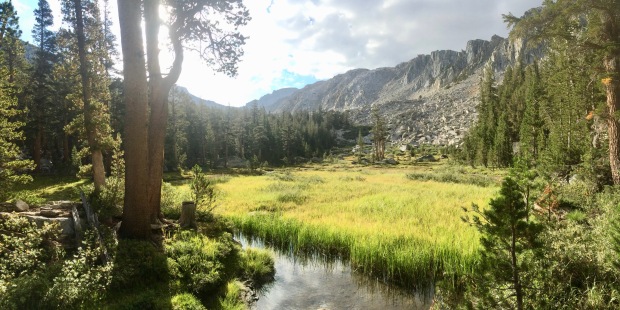
Morning at Lake Virginia. You think a day like this would have started with a more ominous view or something, but nope, ’twas lovely
We hit the trail at 0630 with a quick stop on the shore to filter water and take in the view one last time. Lake Virginia truly was beautiful and although it had been a short little visit, I really enjoyed it. We climbed a bit up from the lake over a saddle and then the views opened up overlooking the gorgeous Tully Hole. I had read that Tully was always hell due to the insane amount of mosquitoes, but I was hoping that since we were later into the hiking season that we’d miss them. We made our way down the steep slope via long switchbacks, when my stomach started to hurt. I darted ahead of the guys and off the trail behind a large downed-tree. This wasn’t looking good. We had a long day ahead and had to get to the shore of Lake Edison in time for the ferry. I was in a ton of pain and was praying this wasn’t Giardia.

Early morning heading down into Tully Hole. That’s what she said, heh heh
Giardia is a parasite often associated with water contamination and poor hygiene in the wilderness. It can take anywhere from 48 hours up to a couple weeks for symptoms to set it, so it’s difficult to pinpoint where and when it starts. I’ll spare everyone the details, but I’m sure you can imagine the gross symptoms which in the wilderness pose a serious threat if you become dehydrated and continue to lose much-needed nutrition. I made it a point to drink lots and lots of fluids this day even if it meant having to stop constantly to hide behind a tree. Luckily my friends were ridiculously supportive. We were all in this together and on a mission to make it to VVR.


Vancouver heading down the steep slope to Tully Hole
Down and down we ended up in Tully Hole which ended up being beautiful and full of people just waking up. There weren’t any mosquitoes at all, making the cold, shaded hike through Tully Hole along Fish Creek an enjoyable part of the day. There were deep swimming holes galore and I wished we had time to stop and play. Eventually we came to a large footbridge and took some photos as we crossed the river.

Funny how excited I always got to see a manmade structure. Woo! A bridge! Fabulous!


For the past few days I had been seeing a ton of trail blazes cut into trees. They looked like a lowercase letter I (i) and I kept wondering if they were part of Inyo or if they were for the PCT. We had left Inyo and were now in Sierra National Forest, so the Inyo logic was tossed. I love seeing old reassurance markers that change as trees grow and collected photos along the way. Major trails often have their own individual marker, so the thought of the PCT having one made sense, but it turns out the lowercase I is actually the standard Forest Service blaze.


Over Fish Creek we continued along through the remnants of former avalanches and took our junction up toward Silver Pass. This little part of the hike, while uphill, was lovely as it crossed the creek a few times and made its way around a gorgeous meadow. It was here that Vancouver sped up ahead telling us he’d wait at the pass and we kept yo-yoing with an older couple. I felt so slow and so ill. I couldn’t imagine actually getting to VVR this day. There were adorable little campsites nestled in near a wooden footbridge by the meadow and I was tempted to stop and stay to see if I could remedy my poor body’s condition with whatever meds I had left in my first aid kit. But I’m stubborn and Jace would be meeting me at VVR, so I pushed on despite wanting to die with every step.
Vancouver taking up the lead to Silver Pass
Just leave me here to die, okay? Okay.
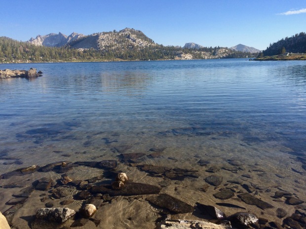
It became steeper as we climbed up toward Silver Pass, but leveled out just in time as we approached the beautiful Squaw Lake. As the skies opened up around us, we saw ominous dark clouds making their way toward us in the distance. The wind was quickly picking up, making us super nervous about getting over the pass in time. “Don’t worry, if it’s going to lightning, we’ll feel the static around us,” said Pete with a grin as we hopped over some large boulders to cross the lake outlet. All joking aside, we knew we’d need to turn back and hunker down to let the storm pass if it were to get much worse and definitely if we saw signs of lightning heading our way. A big part of starting early each day is to minimize the risk associated with afternoon storms. The Sierras are incredibly unpredictable and the weather can get pretty crazy, very quickly. Most hikers aim to get up and over mountain passes by the early afternoon to avoid running into storms and to beat the afternoon heat. It was still only late morning, so this caught us mildly by surprise.
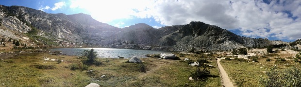
Squaw lake and mildly ominous-looking clouds starting to gather

Looking down over Squaw Lake

Minnesota Pete taking in the views and most likely cursing how slow I hike in front of him
As we got to the top of Silver Pass, we caught up with Vancouver who had sat down to wait for us. I had originally wanted to stop for a snack here on the pass, but we needed to get down the other side before the weather got any worse. The wind was howling and it was getting cold, so we changed into warmer rain gear a little down the trail. The views opened up even more ahead of us and the downhill grade eased as we made our way past lakes and back into the tree line. We made a couple small stream crossings and down into a glacier-carved valley. Finally, the heat was upon us, but we thankfully found a nice little water hole to soak our feet in as we rested and ate our lunch by the water.
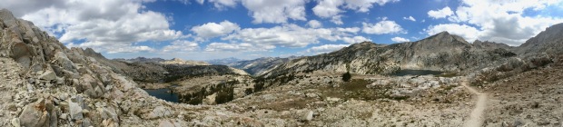
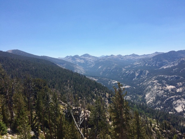
Northwest view from Silver Pass

And Southeast, where we were heading


The guys leading the way down off of Silver Pass


Back at it, the descent toward Lake Edison continued as the heat picked up. I looked at my thermometer and it said it was nearly 90 degrees. My stomach continued to hurt and I’d need to stop every 45 minutes or so to find a tree to hide behind. I felt beyond awful and the scorching heat wasn’t helping. I couldn’t wait to get to the lake, hopefully early, and hop in for a swim.

The whole time heading down this I felt bad for those going up. It was steep and hot


On and on we miserably went in the heat until we reached the junction for Lake Edison Trail. Only a mile and a half to the ferry landing, although we had heard we’d have to hike a bit farther to get where boats could dock since the water level was so low.


We arrived at 1445! Two hours before the ferry would arrive, but there were already two NOBO guys there who beat us. Rather than taking Bear Creek to VVR, they had heard there was cell service on this side of the lake, so they went out of the way and added a ferry to be able to contact friends and family at home. Not going to lie, it was nice to be able to contact Jace to make sure we were still on schedule to meet up the next day. I posted online that I was still somehow alive and that I was waiting for a ferry to take me to free beer. [VVR offers your first round on the house to JMT and PCT hikers- YES!]
I had wanted so badly to swim once I arrived, but the wind was insane and freezing cold, so I took the time to rinse out my clothes, dip my feet, and let everything dry in the strong wind. We were all wondering what happened with Great Legs (Joe). He didn’t look well at all when we left Red’s a couple days ago. We were really hoping he’d be able to catch up and grab his permit from Pete, even though VVR wasn’t part of their original plan. We tried calling, but it went straight to voicemail, so we took it as him being back on the trail again.

Waiting for the ferry… …….. ……… …. … ……. …
[Take note: no more photos for the rest of the day so it clearly gets to a point where I’m over it]
1645 rolled around with no boat in sight and a long line of us dreaming of what waited on the other side of the lake. We waited and waited and then I finally called to see if it was running at all, which they told us it was. Figuring they were probably driving slow since the wind made the water choppy, we waited and waited some more until the tiniest little boat arrived. We sat there stunned. There was no way they could get all of us and our gear across the lake even with a couple trips. The man driving the boat yelled out that he could only take three of us and that he wouldn’t be coming back. It was either sleep there or hike an extra 6 miles mostly uphill to the other side. I wanted to cry.
The two boys ahead of us obviously got on, so it left Minnesota Pete, Vancouver, and me to figure out who would be getting on with them. Vancouver already had a bed booked and needed to stay on schedule since he was heading out again in the morning. He was aiming to finish a few days before I was. Minnesota was contemplating bailing altogether if he could catch a ride up to Fresno to fly home and I had an entire zero day to spend with Jace. It only made sense to have him get on so that he could rest up for his day ahead. We asked him to book some beds for us as well if there were any and to beg them to keep the kitchen open a little longer for us if we could make it. He promised he would, and hopped on the boat.
To this day, Scott (Vancouver) still apologizes for getting on that damn boat and I always tell him it was the right move between all three of us. (Seriously, Vancouver, it’s all good! :]) Whoever got on would be feeling that guilt, so I truly don’t hold it against him even in the slightest! Even that day I wasn’t mad at Scott, I was just mad in general about how my body was fighting against me and how we were told the ferry was running just fine even though it wasn’t. Hiking the extra 6 put me at just over a 20-mile day, which I like to pat myself on the back for instead of sulking over. It was my longest day on the trail and I like to wear it as a little badge rather than think of it as JMT: 1 Jaimie: 0.
So, Pete and I filtered a little more water and off we went in silence. We were both in the worst mood. He was hiking super fast and I couldn’t keep up. I’d constantly wince over in pain holding my stomach to try and make it go away, but I had to keep stopping to hide behind a tree. It was a bummer for sure. I’m finding myself sitting here slamming the keyboard keys, hate-typing about this little section of the trail, haha. We eventually both cooled off, got back to our normal pace, and started talking and joking around again. After a couple hours, darkness started to fall just as we got to a paved road that led us to Vermilion Valley Resort. I was soaked in sweat. Not just from hiking, but from whatever was making me sick. Even still, I was starving and felt dizzy. I needed water and something to eat immediately.
We busted into the dining hall just as they were about to close to find Vancouver and a few others waiting. They kept the kitchen open for us! I was so out of it. I remember sitting there, stunned, and feeling like I was going to fall over. A fever was setting in. I ordered a giant water, my free beer (!!!!!), and some pasta with fresh basil. I took a bunch of medicine and did my best to eat and drink what I could.
Vancouver saved the day. He was able to reserve me my own RV Trailer for the next two nights. He carried my stuff over for me, said goodnight, and I stumbled in and ran to the bathroom. Only Jace knows this until now, but I sat in there bawling my eyes out. It was the first time I cried on the trail. My insides were twisted and on fire. The medicine hadn’t kicked in yet, and my fever was getting worse. To top it all off, there wasn’t any toilet paper. Yep. I wanted to die. I was in hysterics and all my emotions came spilling out. After I pulled myself together and figured out how to proceed (definitely leaving that part out), I headed back to the front desk to grab 761281782654 rolls of toilet paper from the nice girl who worked there. She had noticed I was crying and I told her how sick I was. She was the sweetest thing (Former PCT hiker… dark hair… beanie… I really wish I could remember her name…) and told me if I needed a doctor or any help at all that she would do everything she could. I headed back to my humble little Holiday Rambler and as lame as it is, I cried myself to sleep that night curled up in the tiniest ball on my bed jokingly thinking, “So this is how I die.”
But I’m not going to end Day 9 on that note. Nope, nope.
Day 9 officially put me at over 100 MILES of walking on this trail! Amazing! While I was only at mile 89.6 of the JMT at the Lake Edison Trail Junction, there had been extra added mileage along the way with hiking to different campsites and resupplies off trail. Something to be proud of for sure.
Before starting this part of the tripsandtrailmix blog I asked everyone I hiked with if I could write about them. I loved Scott’s response: “Sure, go for it in your blog. I must say that I felt like a real shit sitting on that boat. I did finish on the 10th (I had until the 11th), so no zero days but it was awesome. A few days I was wondering where you were at the time – it was interesting to know that if you were two days ahead or behind, you’d run into an entirely different group of people.” He was so right. I had fallen into this little group of friends after being alone for a week and was sad that it was soon to be ending. Great Legs was somewhere a day or two behind, Vancouver would be two days ahead, and Minnesota was potentially heading out.
I was looking forward to hopefully being alive the next morning (*spoiler alert for Day 10: I was*) and having breakfast with my friends one last time. Jace was also going to be getting there sometime in the early afternoon. There were showers. Laundry. I had a whole RV to myself. There was fresh food. Beer. (Seriously, TONS of amazing beer varieties and micro brews!) VVR was a little oasis with great hiker-friendly staff and I was excited for my zero day ahead.

Ignore my ridiculous scribbles. I woke up that morning and read a bit from my book. I took a screen shot of this quote and looking at it now I wish I had remembered to look at it before going to bed feeling so defeated. ❤